South America / Bolivia

Cochabamba.

Places to go. A little room to wander.

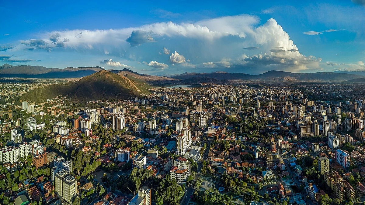
A local view near Cochabamba, Bolivia
A local view near Cochabamba, Bolivia. Photograph by Parallelepiped09 · CC BY-SA 4.0 · Resized and converted to WebP.

THE SHORTLIST

A few places worth your time.

01Neighborhoods · DAY 1 IDEA

Cochabamba

Plaza de Las Banderas

If you are interested in seeing different flags of the world on display, this might be of interest. But it makes for a pleasant stop if walking along the prado, and sometimes there are arts and crafts on display.

Allow about 60 minutes · planning estimate

Map Source
02Culture · DAY 1 IDEA

Av. Potosí 1450

Simón I. Patiño Cultural Center

Includes the Palacio Portales mansion, gardens (Jardines), and an art museum (Centro de Arte Contemporáneo). The mansion was built by Patiño, a tin magnate who controlled over half of the nation's output in the 1930s.

Allow about 90 minutes · planning estimate

Map Source
03Neighborhoods · DAY 1 IDEA

Bolivar and Plaza 14 de Septiembre

Plaza de Armas, September 14

City center, site of commemoration of Bolivia's independence, where you can feed the pigeons and look at the Metropolitan Catedral of Saint Sebastian.

Allow about 60 minutes · planning estimate

Map Source
04Culture · DAY 2 IDEA

Av de la Concordia

Cristo de la Concordia

The statue is just a bit higher and larger than the one in Rio de Janeiro, making it the world's largest statue of Jesus until 2010, when a larger one was completed in Poland. It offers a great view of the city. Walk Calle Colombia until its eastern end, then a swift right: This park/playground is where the cable car goes from, Bs. 6.50 each way. You can also walk. After sunset it is better to go in a group of 4 or more.

Allow about 90 minutes · planning estimate

Map Source
05Outdoors · DAY 2 IDEA

Regional outing · 27 km from Cochabamba (straight line)

Tunari National Park

Height: . This mountain can be done without a guide, but you need to take care and be aware of water, sun and altitude. It is a 4-hr climb one-way, so you need to start early. First you go to Quillacollo, where you transfer by taxi or other transport towards the mountain and its trailhead. Best ask your hostel or hotel which are the exact buses and destinations. The hotel might also recommend a local guide if you want.

Allow about 60 minutes · planning estimate

Map Source

A note before you go. Treat Tunari National Park as a separate regional outing from Cochabamba. Arrange the outward and return journey before adding another visit on that day. The suggested days are an editable grouping, not a timed tour. Visit allowances exclude transfers, meals and queues; confirm the exact entrance and current visiting arrangements for Tunari National Park before setting off.

Reference material retrieved 2026-10-19. Suggested days and time allowances are editorial starting points. Check the linked visitor information for opening hours, access, and reservations.

BEFORE YOU SET OFF

A more practical kind of plan.

Getting your bearings

Cochabamba has buses (micros), mini-vans (trufis) and shared cabs (taxi-trufis) that run along fixed routes. There are no set stops and in order to get off, you must say "me bajo" (I want to get off) or "esquina" (for stop at the corner). It's recommended to take radio taxis in the evenings.

Build a route that makes sense

Plaza de Las Banderas and Simón I. Patiño Cultural Center are about 1.1 km apart in a straight line. Use the route link to compare the actual streets or transport connections before putting both in the same morning; the measurement is not a walking distance or a transfer estimate.

A LITTLE STRUCTURE. ROOM FOR DISCOVERY.

Your Cochabamba plan.

Add a few stops, choose your days, and leave space between them.

My saved trips
Location, map & reference details

Find your bearings.

Country
Bolivia
Area
Cochabamba
Time zone
America/La_Paz
Coordinates
-17.3819, -66.1599

Geographic reference: GeoNames, CC BY 4.0.

Cochabamba

Loading this map connects to OpenStreetMap.

Visitor information & sources

Reference credits & reuse

This city guide includes selected, abridged material by Wikivoyage contributors, adapted under CC BY-SA 4.0. The adapted guide text is available under the same license; photographs and website design retain their separate terms. Selected and abridged reference descriptions; operational prices and timetables omitted. Elsewhere added the shortlist, geographic grouping and planning notes.

Reference material retrieved 2026-10-19. It is community-edited background, not firsthand reporting or a live opening-hours service.

KEEP EXPLORING

More places in Bolivia.

Browse the country
A WORLD OF POSSIBILITIES

Where to next?

Search 600 places across 100 countries.