Asia / Vietnam

Da Nang.

Places to go. A little room to wander.

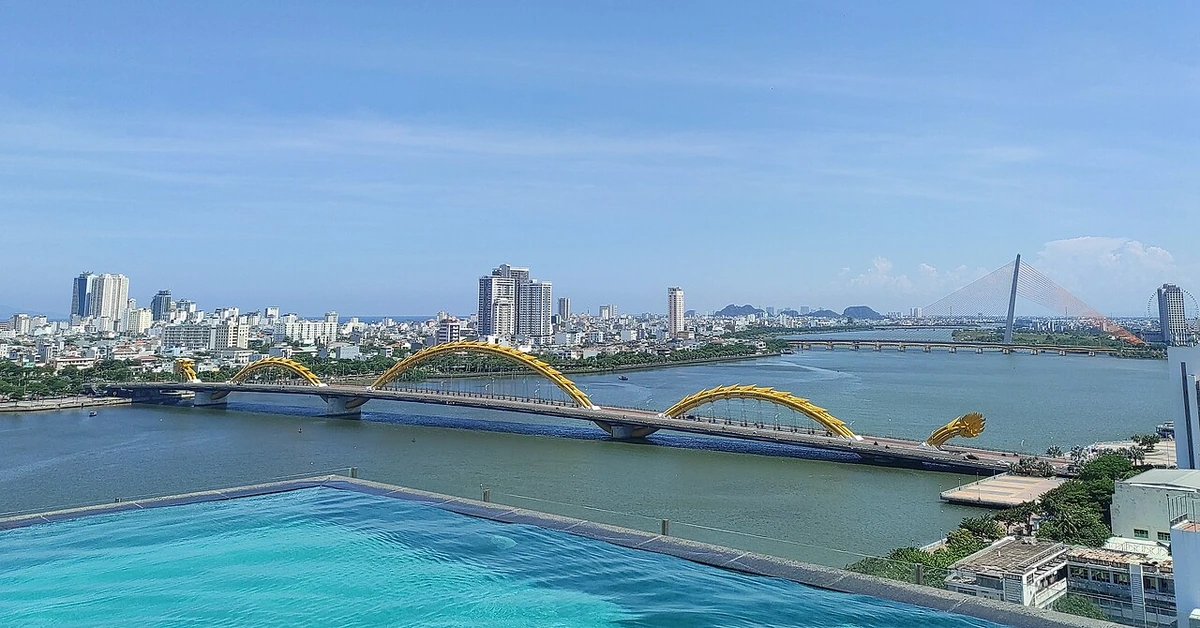
A local view near Da Nang, Vietnam
A local view near Da Nang, Vietnam. Photograph by Somerset999 · CC BY-SA 4.0 · Resized proportionally, EXIF orientation applied, converted to high-quality WebP (quality 92); no content edits.

THE SHORTLIST

A few places worth your time.

01Outdoors · DAY 1 IDEA

along Bach Dang Rd

Han River Promenade

The beauty of the Han River has inspired poets and composers throughout Da Nang's history, and any local will probably be able to sing you a few lines of Sông Hàn Tình Yêu Của Tôi (Han River, My Love) as they stroll the edge of the water. The promenade on the western bank of the river is well built up, stretching from the Dragon Bridge in the south to the city port in the north.

Allow about 60 minutes · planning estimate

Map Source
02Culture · DAY 1 IDEA

2, September 2nd Rd

Museum of Cham Sculpture

Founded in 1915 by the École Française d'Extrême Orient, it houses a collection of stone sculptures from the Hindu-practicing Cham civilization, which occupied much of central Vietnam in the first millennium CE to about the 14th century. The museum can be toured in about an hour. The sculptures are nearly all made of sandstone, and some have weathered badly over the centuries, but you can still appreciate the delightful artistic quality of the figures, which include shiva, garudas, nagas, lions, monkeys, and elephants.

Allow about 90 minutes · planning estimate

Map Source
03Culture · DAY 1 IDEA

Hoang Sa Rd

Linh Ung Temple

Located on Son Tra Mountain and clearly visible from My Khe Beach, this temple has stunning views of the sea, the sky, and a 67-m tall statue of "Quan The Am" (Guanyin, the Goddess of Mercy) facing the ocean. The pagoda was built in 2010.

Allow about 90 minutes · planning estimate

Map Source
04Outdoors · DAY 2 IDEA

Da Nang

Marble Mountains

The group includes Kim Son (Mountain of Metal), Moc Son (Mountain of Wood), Thuy Son (Mountain of Water), Hoa Son (Mountain of Fire), and Tho Son (Mountain of Earth). Several Buddhist temples have been built into the caves and grottoes, and it's a popular pilgrimage site.

Allow about 60 minutes · planning estimate

Map Source
05Outdoors · DAY 2 IDEA

Regional outing · 21 km from Da Nang (straight line)

Ba Na Hill Station

Ba Na is 1,487 m above sea level in the Truong Son Mountains. In the 1920s, it was a French resort that boasted 200 villas, restaurants, and clubs. It is known as the second Dalat or Sa Pa in central Vietnam. Its temperate climate, unspoiled forest, and spectacular views over the South China Sea and the Lao mountains made Ba Na a popular retreat for both the French and the wealthy Vietnamese.

Allow about 60 minutes · planning estimate

Map Source

A note before you go. Treat Ba Na Hill Station as a separate regional outing from Da Nang. Arrange the outward and return journey before adding another visit on that day. The suggested days are an editable grouping, not a timed tour. Visit allowances exclude transfers, meals and queues; confirm the exact entrance and current visiting arrangements for Ba Na Hill Station before setting off.

Reference material retrieved 2026-10-19. Suggested days and time allowances are editorial starting points. Check the linked visitor information for opening hours, access, and reservations.
BEFORE YOU SET OFF

A more practical kind of plan.

Getting your bearings

All riders are now required to wear helmets, a rule that is strongly enforced. Make sure the driver supplies you with a helmet. If he doesn't, find another one, as you'll be the one stung for the fine. Short hops around town shouldn't be more than 20,000 dong, if you go between districts this increases and all the way to the airport around 70,000 dong. Drivers are generally quite friendly and will go slower upon request. They are also not adverse to a bear hug if you are really struggling to hold on to the motorbike.

Build a route that makes sense

Han River Promenade and Museum of Cham Sculpture are about 0.6 km apart in a straight line. Use the route link to compare the actual streets or transport connections before putting both in the same morning; the measurement is not a walking distance or a transfer estimate.

A LITTLE STRUCTURE. ROOM FOR DISCOVERY.

Your Da Nang plan.

Add a few stops, choose your days, and leave space between them.

My saved trips
Location, map & reference details

Find your bearings.

Country
Vietnam
Area
Da Nang City
Time zone
Asia/Ho_Chi_Minh
Coordinates
16.0678, 108.2208

Geographic reference: GeoNames, CC BY 4.0.

Da Nang

Loading this map connects to OpenStreetMap.

Visitor information & sources

Reference credits & reuse

This city guide includes selected, abridged material by Wikivoyage contributors, adapted under CC BY-SA 4.0. The adapted guide text is available under the same license; photographs and website design retain their separate terms. Selected and abridged reference descriptions; operational prices and timetables omitted. Elsewhere added the shortlist, geographic grouping and planning notes.

Reference material retrieved 2026-10-19. It is community-edited background, not firsthand reporting or a live opening-hours service.

KEEP EXPLORING

More places in Vietnam.

Browse the country
A WORLD OF POSSIBILITIES

Where to next?

Search 600 places across 100 countries.