Asia / Bhutan

Punākha.

Places to go. A little room to wander.

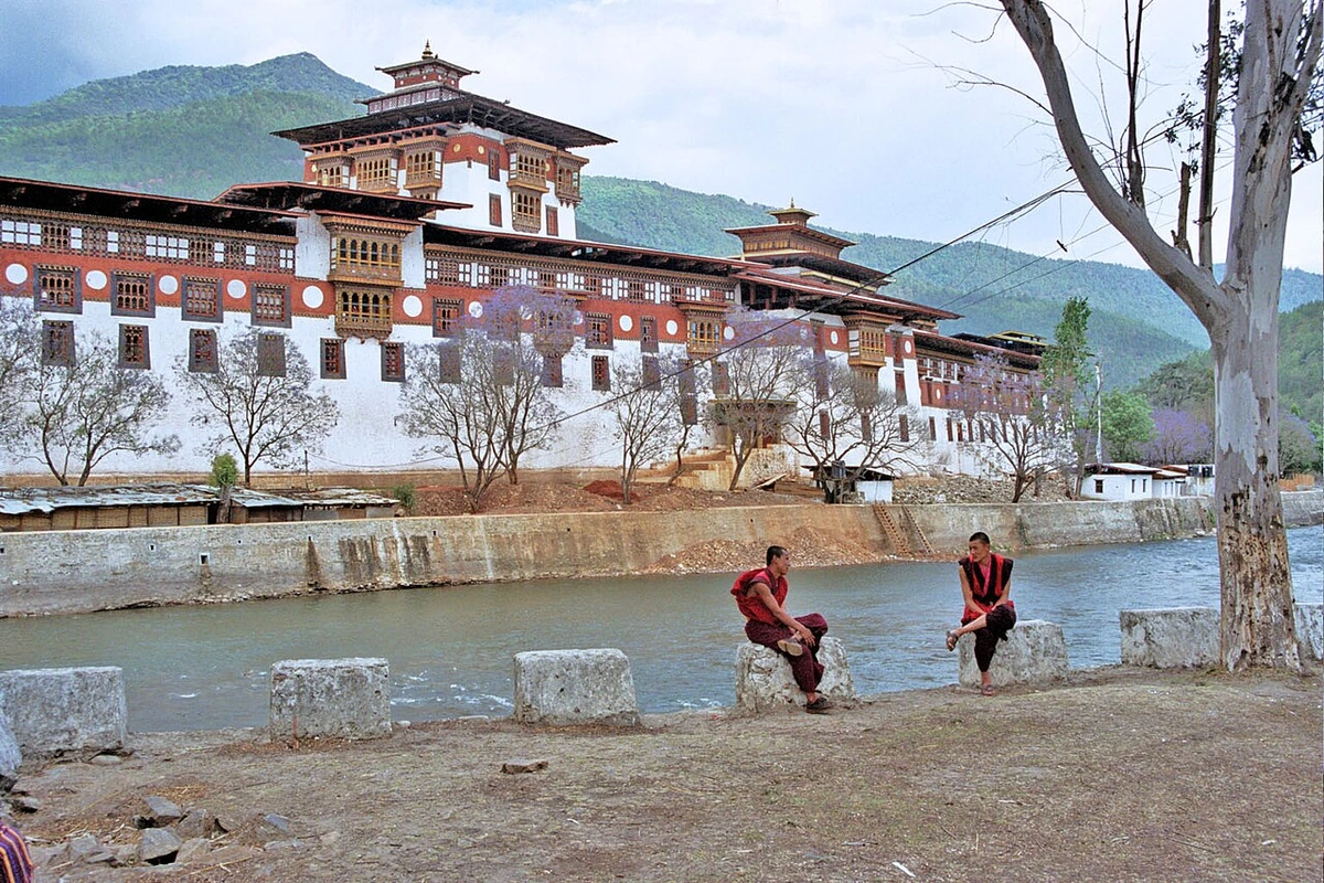
A local view near Punākha, Bhutan
A local view near Punākha, Bhutan. Photograph by The original uploader was Technopilgrim at English Wikipedia . · CC BY-SA 3.0 · Resized and converted to WebP.

THE SHORTLIST

A few places worth your time.

01Culture · DAY 1 IDEA

Punākha

Punakha Suspension Bridge

An almost 250 m long pedestrian suspension bridge built in 16th century across one of the Mochu/Phochu rivers. It's very beautiful and serene, very good to sit and just watch the flow of the river. Many people do not visit this, but those who have would consider it as a must go. It is also a checkpoint for the annual Bhutan International Marathon.

Allow about 90 minutes · planning estimate

Map Source
02Culture · DAY 1 IDEA

Punākha

Chimi Lhakhang

Between very beautiful paddy fields, it is one of the most scenic monasteries in eastern Bhutan and takes about half an hour to trek/walk till the monastery from the road. Best time of day to visit: early morning. It was established by Drukpa Kunley, who also is credited with introducing to the country the practice of phallus paintings, and placing statues of phalluses on rooftops, to drive away evil spirits. Bhutanese come here to seek for fertility blessing.

Allow about 90 minutes · planning estimate

Map Source
03Culture · DAY 1 IDEA

Punākha

Punakha Dzong

Majestically standing on an island between the confluence of the Pho Chhu and Mo Chhu rivers, the city's dzong is one of the most photogenic of all Bhutan's ancient fortresses, and you will see pictures of it hanging in hotels and restaurants throughout the country. It was constructed without an architectural blueprint or using any nails. The dzong is joined to the mainland by an arched wooden bridge, and contains many precious relics from the days when successive kings reigned the kingdom from this valley.

Allow about 90 minutes · planning estimate

Map Source
04Culture · DAY 2 IDEA

Punākha

Geon Tsephu (Guru Rinpoche Caves)

. A short drive up a rough road or two hour walk from the highway at Mitesgang, there is a small temple and sacred caves. It is said that Guru Rinpoche visited these caves after his retreat at Maratika in Nepal, and it was here that he was able to fully see the form of Amitayus, the Buddha of Long Life. As is common at many Bhutanese sacred sites, there are self risen characters in rock and places to scramble through while making dedications for the benefit of other beings and to remove one's own defilements. Pilgrims can lay their bedding at the temple or use the pasture just below for camping (though leeches are common in the summer). Mitesgang is around 12km down the valley Punakha Dzong.

Allow about 90 minutes · planning estimate

Map Source
05Culture · DAY 2 IDEA

Regional outing · confirm exact location and transfers

Koma Tsachu (Hot springs)

are near the small community of Mitesgang. There are three bathing pools covered by simple roofs, and a four-roomed building with solar lighting, where sleeping bags and mats can be laid (there is no charge for staying in the building). Outside, there is ample room to pitch tents and rock overhangs to camp under.

Allow about 90 minutes · planning estimate

Map Source

A note before you go. Start with Punakha Suspension Bridge, then decide whether Chimi Lhakhang deserves a separate visit rather than rushing both. The suggested days are an editable grouping, not a timed tour. Visit allowances exclude transfers, meals and queues; confirm the exact entrance and current visiting arrangements for Koma Tsachu (Hot springs) before setting off.

Reference material retrieved 2026-10-19. Suggested days and time allowances are editorial starting points. Check the linked visitor information for opening hours, access, and reservations.

BEFORE YOU SET OFF

A more practical kind of plan.

Getting your bearings

All attractions in the town (including the dzong) can be reached on foot. There is a taxi rank near the dzong, where taxis can be hired for visiting sites of interest outside the town, but within the valley.

Build a route that makes sense

Punakha Suspension Bridge and Chimi Lhakhang are about 7.0 km apart in a straight line. Use the route link to compare the actual streets or transport connections before putting both in the same morning; the measurement is not a walking distance or a transfer estimate.

A LITTLE STRUCTURE. ROOM FOR DISCOVERY.

Your Punākha plan.

Add a few stops, choose your days, and leave space between them.

My saved trips
Location, map & reference details

Find your bearings.

Country
Bhutan
Area
Punakha
Time zone
Asia/Thimphu
Coordinates
27.5914, 89.8774

Geographic reference: GeoNames, CC BY 4.0.

Punākha

Loading this map connects to OpenStreetMap.

Visitor information & sources

Reference credits & reuse

This city guide includes selected, abridged material by Wikivoyage contributors, adapted under CC BY-SA 4.0. The adapted guide text is available under the same license; photographs and website design retain their separate terms. Selected and abridged reference descriptions; operational prices and timetables omitted. Elsewhere added the shortlist, geographic grouping and planning notes.

Reference material retrieved 2026-10-19. It is community-edited background, not firsthand reporting or a live opening-hours service.

KEEP EXPLORING

More places in Bhutan.

Browse the country
A WORLD OF POSSIBILITIES

Where to next?

Search 600 places across 100 countries.